
Something haunting happens when you stand in the ruins of a place once teeming with life. The silence speaks louder than the remaining stone walls. Archaeologists in recent years have uncovered astonishing new evidence about why some of history’s mightiest urban centers fell into darkness, and it’s not always the story we’ve been told. Modern technology like LiDAR scanning and ground-penetrating radar are revealing secrets buried for centuries.
In 2024, researchers identified over 6,000 separate buildings making up an advanced Maya city now designated Valeriana, hidden beneath Mexican jungle canopy. Meanwhile, discoveries beneath Petra’s famous Treasury and fresh evidence from Pompeii’s ruins continue reshaping what we know about these lost worlds.
Angkor Wat: When Climate Became the Enemy
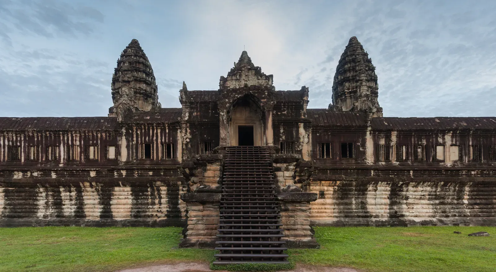
Intense monsoon rains that followed a prolonged drought in the region caused widespread damage to the city’s infrastructure, leading to its collapse. The Angkor civilization wasn’t destroyed in a single dramatic invasion, though that’s the story many history books tell. While Thai chronicles state the city was attacked by the neighboring Kingdom of Ayutthaya in 1431 CE, the reality was far more complex.
Tree ring evidence revealed a mega-drought lasting three decades from the 1330s to 1360s, followed by a more severe but shorter drought from the 1400s to 1420s. Think about it: thirty years without adequate water for the massive irrigation system that fed the entire civilization. The problem was not drought or flood, but variability between both, and the collapse of the water network due to a combination of intense summer monsoon rains and lack of maintenance.
Core samples from the early 14th century showed a massive decrease in pollen and charcoal deposits, and showed little evidence of soil erosion, all pointing to a decrease in farming practices. The city didn’t vanish overnight. Angkor’s collapse may be better described as a transformation, as people gradually relocated to trading centers along rivers with better access to maritime commerce.
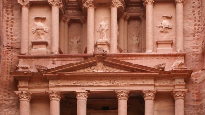
Petra: The Desert City Hiding Tombs Beneath Its Treasures
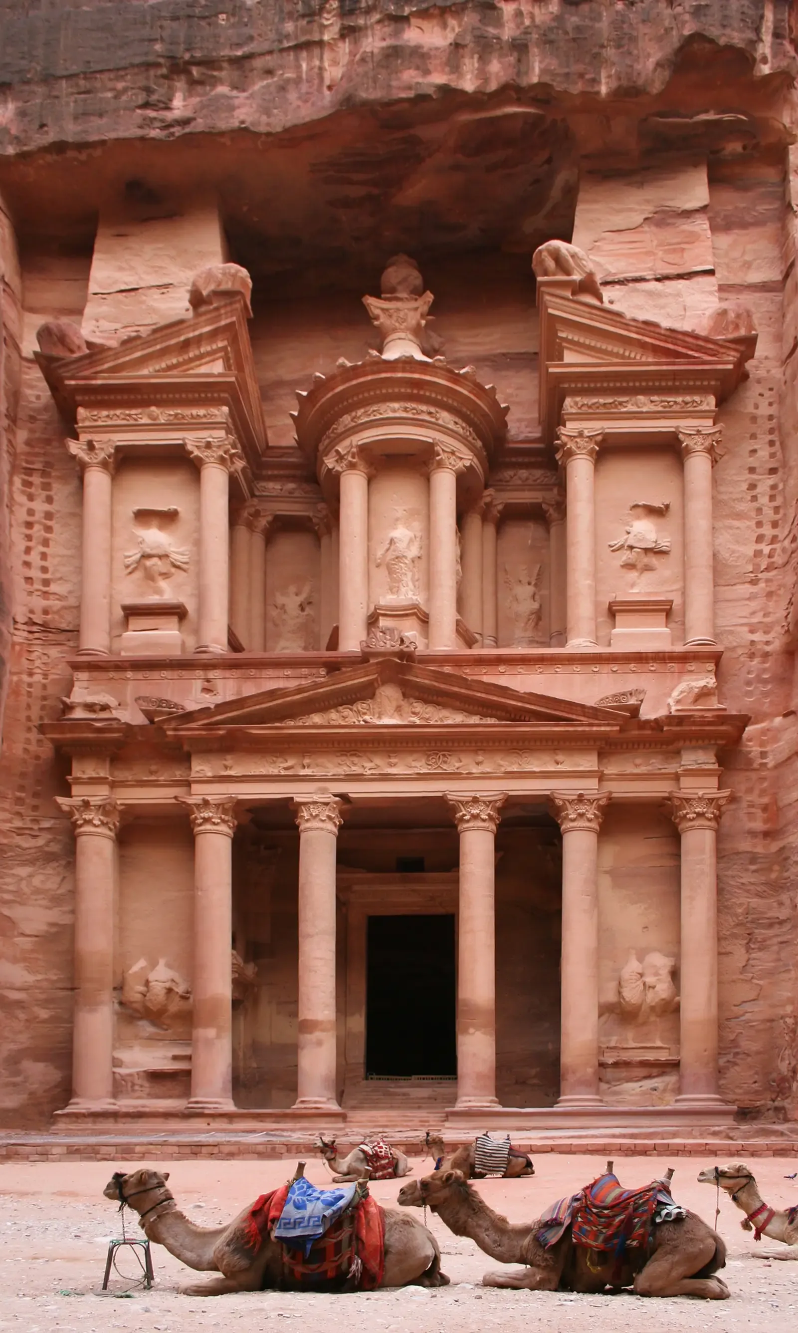
Carved into rose-colored sandstone cliffs two millennia ago, Petra continues to surprise us. In October 2024, excavation revealed a previously unknown tomb containing 12 skeletons and artifacts that are estimated to be around 2,000 years old, right beneath the famous Treasury monument that millions recognize from Indiana Jones movies.
The tomb contains about 12 skeletons ranging in age between children and adults. What makes this discovery remarkable isn’t just the number of bodies. Only a few tombs in the Petra area have ever contained any human remains, and those are very fragmentary, whereas this has got 12 complete bodies within it.
The tomb was most likely built as a mausoleum and crypt in the Nabatean Kingdom at the beginning of the first century AD, though like many tombs in the valley, few remains have ever been found in the tombs due to their subsequent use and reuse over the last two millennia. The Nabataeans themselves remain somewhat mysterious. For a nomadic people, Petra was a settlement where they were carving stone mausoleums, but very little evidence of their daily lives and societal structures exists, partly because the Romans came in very soon afterwards.
Teotihuacan: The Place Where Gods Were Created
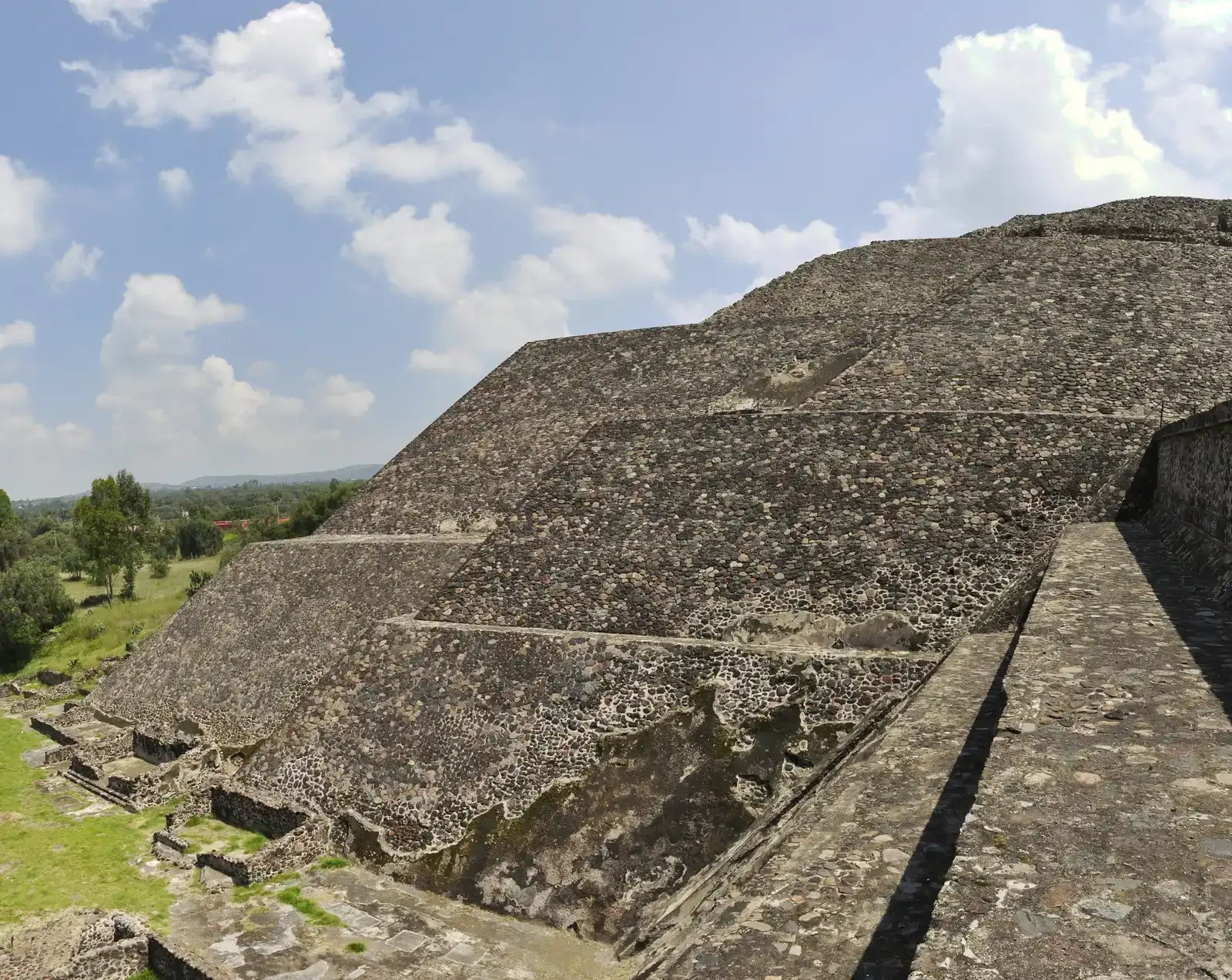
At its zenith, perhaps in the first half of the first millennium, Teotihuacan was the largest city in the Americas, with a population of at least 25,000, but has been estimated at 125,000 or more. The Aztecs, arriving centuries after its abandonment, couldn’t believe humans built such monumental pyramids. They named it Teotihuacan, meaning birthplace of the gods.
Here’s the thing: we still don’t know who built it. The city may have lasted until sometime between the 7th and 8th centuries CE, but its major monuments were sacked and systematically burned around 550 CE, and its collapse might be related to the extreme weather events of 535-536.
Around 600 AD, major buildings were deliberately burned and artworks and religious sculptures were destroyed, suggesting an uprising from the poor against the ruling elite. Yet some researchers propose a different culprit. Five ancient earthquakes have been determined from the damage, dated from the Tzacualli cultural period to the Xolalpan-Metepec period, and repetitive megathrust earthquakes from the Middle American Trench could be responsible for the spatial pattern of the building damage. One of the biggest discoveries yielded by excavations in recent summers was evidence of a great fire, with charred walls and carbonized matter prompting questions about whether this mysterious fire was the cause of Teotihuacan’s collapse after thriving for centuries.
Pompeii: Frozen in Time by Volcanic Fury
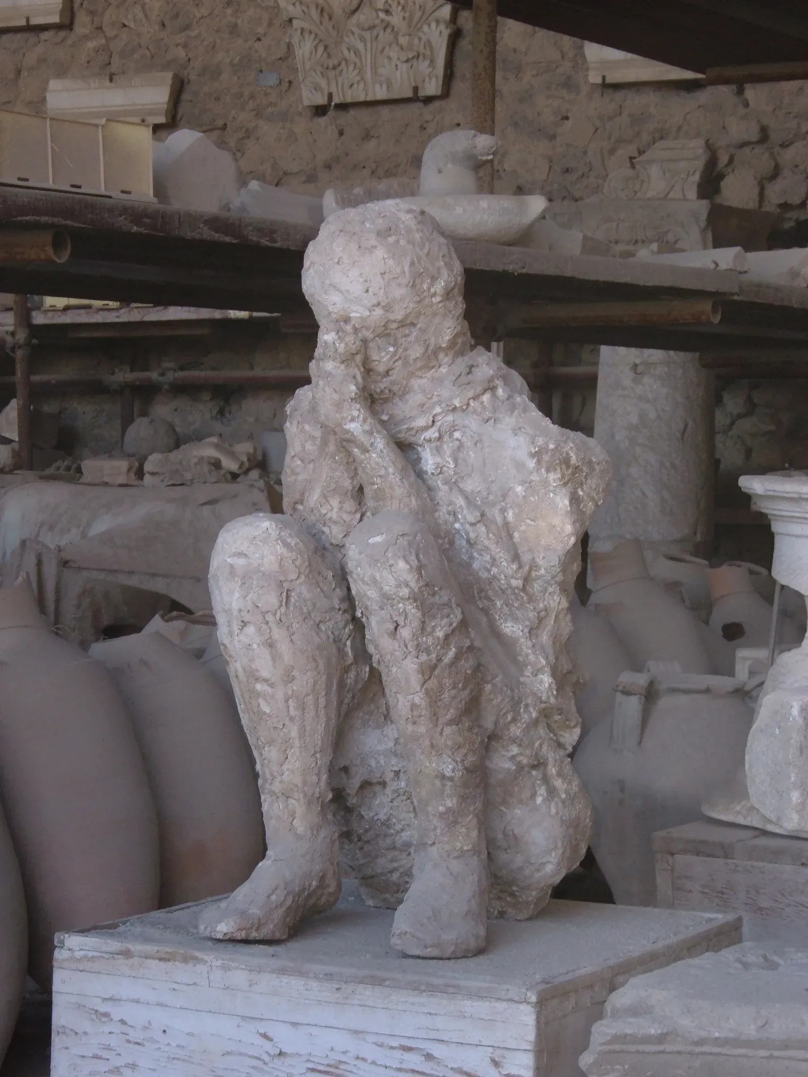
Everyone knows the basic story. In 79 AD, Mount Vesuvius erupted, ejecting molten rock, pulverized pumice and hot ash at 1.5 million tons per second, ultimately releasing 100,000 times the thermal energy of the atomic bombings of Hiroshima and Nagasaki. What you might not know is that the traditional date is disputed.
In October 2018, Italian archaeologists uncovered a charcoal inscription reading the 16th day before the calends of November, or October 17, that was probably made by a worker renovating a home, and which has subsequently been suggested as the most likely date for the eruption. Archaeologists discovered remnants of autumnal fruits such as the pomegranate, the remains of victims in heavy clothing, and large earthenware storage vessels laden with wine, and the wine-related discovery suggests that the eruption might have happened after the grape harvest.
When Mount Vesuvius erupted, it didn’t just coat nearby cities with lethally hot gas, ash and rock, it also triggered deadly earthquakes, according to a 2024 study. The remains of over 1,500 people have been found at Pompeii and Herculaneum, though the total death toll remains unknown. The pyroclastic surges moved with terrifying speed, instantly killing anyone in their path with temperatures exceeding 400 degrees Celsius.
Thonis-Heracleion: Egypt’s Sunken Port City

Submerged in Abu Qir Bay near Alexandria, Thonis-Heracleion was a major Egyptian port city linking Mediterranean trade with the Nile’s inland economy, and recent phases of underwater missions documented new zones around the Amun temple complex and identified a Greek sanctuary dedicated to Aphrodite east of it. The city thrived as a multicultural commercial gateway before being swallowed by the sea.
The discoveries support Thonis-Heracleion’s role as a multicultural commercial gateway, with religious spaces and trade infrastructure intertwined within a port environment that later became overwhelmed by subsidence and seismic-related flooding. Reporting in August 2025 describes surveys revealing what archaeologists characterize as a complete Roman-era city footprint underwater, including temples, cisterns, quays, and fish tanks, along with recovered statuary and architectural elements, and the picture emerging shows a coastal urban center with substantial waterfront engineering and water-management infrastructure.
The underwater preservation offers researchers an unusual advantage. Between 2024 and early 2026, researchers using advanced diving techniques, geophysical surveys, and 3D reconstruction have revisited some of the world’s most intriguing submerged cities, revealing new details about how they functioned, why they were lost, and what still survives below the waves.
The New Technology Changing Everything We Know
New tools include artificial intelligence, DNA sequencing, satellite imagery, the airborne technology known as LiDAR, drones carrying thermal infrared cameras and tiny robots that can crawl down a tomb shaft. These aren’t just fancy gadgets. They’re rewriting history.
Some of the most dramatic discoveries in recent years have come via LiDAR, which stands for light detection and ranging, and by airplane, helicopter or drone, a LiDAR system aims rapid pulses of laser light at the surface and the reflections are processed to create a three-dimensional map, and advances in LiDAR have improved its ability to penetrate tree canopies and create precise images of the terrain below.
A college student recently employed AI to read ancient scrolls from 2,000 years ago; archaeologists discovered an ancient roman military camp at the top of a mountain; and a lost city was discovered in the Honduran rainforest. There’s a real sense of urgency around site mapping and site detection just because coastal erosion, wildfires, tsunamis and large scale climate events are impacting sites, said Sarah Parcak, an archaeologist at the University of Alabama.
What have we learned from all these lost cities? Climate change isn’t new, though our ability to predict and respond to it is. Internal conflict often delivers the final blow to civilizations already weakened by environmental stress. The grandest monuments can’t save a society that loses its ability to adapt. Did you expect so many of these mighty civilizations to fall not to invading armies, but to something as basic as water, too much or too little?
Human ingenuity built these incredible cities. Human stubbornness sometimes prevented their inhabitants from abandoning them in time. The ruins left behind are more than tourist attractions. They’re warnings written in stone.


