

Storms Deliver Temporary Snowpack Boost (Image Credits: Ca-times.brightspotcdn.com)
California’s Sierra Nevada – Striking NASA satellite imagery documents the rapid erosion of the region’s snowpack after a punishing late-winter heat wave erased recent storm gains.
Storms Deliver Temporary Snowpack Boost
Powerful storms battered the Sierra Nevada in late February 2026, dumping multiple feet of snow across the range in mere days.[1][2]
These events reversed an earlier dismal trend, where the snowpack had languished well below average amid an unusually warm winter. By February 23, the statewide snowpack reached 73% of historical averages, with the southern Sierra hitting 98% of normal levels.[2]
The deluge blanketed lower elevations and filled in barren patches, offering brief hope for water reserves. Yosemite National Park closed temporarily due to the heavy accumulation, and avalanches claimed lives near Lake Tahoe. Yet this buildup proved short-lived.
Record Heat Wave Triggers Swift Meltdown
A heat wave swept through late February into early March, with temperatures soaring 15 to 20 degrees above normal across much of California.[1]
This extreme warmth accelerated melting, retreating snow levels to early February conditions by March 3. Northern Sierra snowpack plunged to 38% of average, while the southern portion held at 83%.[1]
Forecasters predicted continued above-average heat, threatening further losses. The 130 monitoring stations in the Sierra provided real-time data confirming the decline. Precipitation earlier in the season often fell as rain due to the mild conditions.
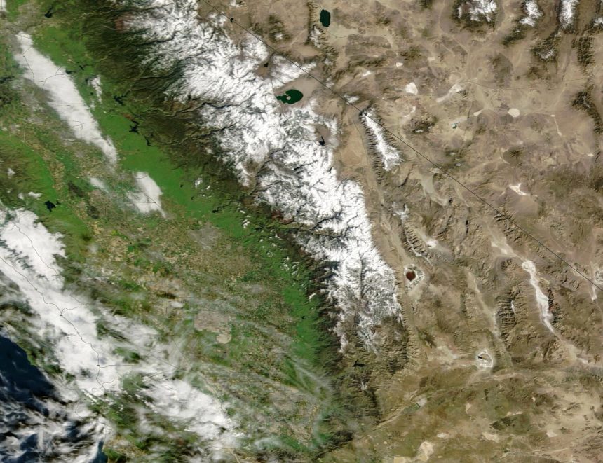
Satellite Views Highlight the Scale
NASA’s Terra satellite captured the transformation clearly. On February 22, expansive snow cover dominated the Sierra Nevada; by March 3, vast areas appeared patchy or bare.[1]
Another comparison showed February 12 conditions nearly identical to those on March 3, underscoring how the late-February snow vanished almost entirely. These images illustrated snow recession across elevations in under 10 days.
- Northern Sierra: Dropped to 38% of average post-heat wave.
- Central Sierra: Significant retreat from peak levels.
- Southern Sierra: Fell from 98% to 83% of normal.
- Statewide: Overall below 70% by early March.
Threats to Water Supply and Beyond
The Sierra snowpack supplies roughly 30% of California’s water, making this early melt a major concern.[1]
Runoff timing shifts earlier, straining reservoirs and extending dry periods into summer. Wildfire risks could rise as parched landscapes dry out sooner.
| Period | Statewide Snowpack | Notes |
|---|---|---|
| Early February | ~55% | Pre-storm low |
| Feb 23 | 73% | Post-storm peak[2] |
| Early March | <70% | Post-heat wave[1] |
Officials monitor conditions closely, but the whiplash from storms to heat underscores seasonal volatility.
Experts Sound Alarm on Climate Trends
Climate scientist Daniel Swain described the melt as unprecedented. “The extremely rapid loss of the snow that fell during the late Feb storm cycle, which in many cases dropped multiple feet of snow in the Sierra Nevada over just a couple of days, is genuinely remarkable,” he stated in an email.[1]
Swain added, “The very early loss of snowpack will effectively make the long, dry summer that much longer in the mountains.” Global warming contributes by elevating snow lines and favoring rain over snow.
Key Takeaways
- Rapid melt erased late-February storm gains in under two weeks.
- Snowpack now regionally variable, overall below average.
- Early losses heighten summer water shortages and fire dangers.
This episode serves as a stark reminder of California’s fragile water balance amid shifting weather extremes. What do you think about these snowpack swings? Tell us in the comments.


