

A Sudden Threat Rolls In (Image Credits: Unsplash)
Middle, Tennessee – A local resident took cover in an interior closet with their dogs last Thursday as a powerful storm barreled through the area, producing an ominous rumble that echoed like a freight train passing overhead.[1] The event left the homeowner questioning whether they had witnessed a tornado, a supercell thunderstorm, or another intense weather phenomenon. This close encounter unfolded amid a marginal risk of severe weather across parts of Middle Tennessee that day.[2]
A Sudden Threat Rolls In
The storm approached rapidly, appearing “pretty nasty” from the resident’s vantage point outside their home. Having grown up in tornado-prone southern Missouri, the individual typically monitors weather closely and only shelters during official warnings. Yet the visual and auditory cues proved too alarming to ignore.
Within minutes, the family retreated indoors and hunkered down. The roar intensified, prompting the shelter decision. No immediate damage reports surfaced from the property, but the experience underscored the raw power of spring storms in the region.[1]
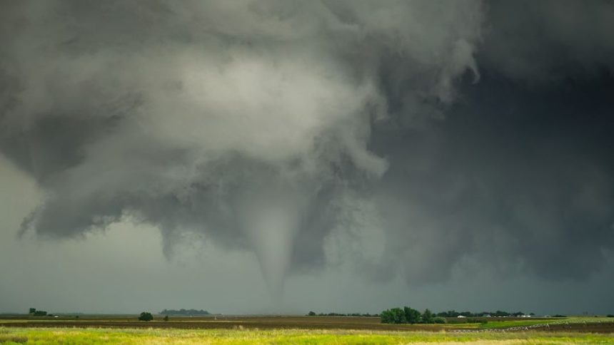
Video Captures the Drama
The homeowner shared a video of the approaching storm on Reddit’s r/tornado forum, sparking discussion about its classification. The footage shows the dark, turbulent cloud formation advancing toward the location in Rutherford County. Viewers debated whether it depicted a wall cloud, inflow bands, or something more sinister like a brief tornado touchdown.[1]
Posted by u/hurtbybadart, the clip quickly drew attention from weather enthusiasts. While no official confirmation emerged labeling it a tornado, the post highlighted how quickly conditions can escalate. The National Weather Service in Nashville had forecasted a slight risk for severe thunderstorms that afternoon and evening, with damaging winds as the primary concern.[3]
Broader Weather Patterns in Play
Middle Tennessee sat under a marginal risk for severe weather on April 24, part of a multi-day pattern leading into stronger threats over the weekend and early the following week. Forecasts warned of isolated storms capable of producing gusty winds, hail, and heavy rain west of Interstate 65.[2] The resident’s account aligns with reports of strong thunderstorms moving through the area.
Just days later, the region faced more intense activity. Overnight storms on April 28 brought confirmed tornadoes near Goodlettsville and Ivy Point, along with widespread power outages affecting thousands.[4][5] Investigations into additional possible twisters continued amid back-to-back severe rounds. These events serve as a reminder of Tennessee’s volatile spring weather.
Lessons from the Shelter
Such incidents emphasize preparedness in storm-prone areas. Residents like this one relied on personal judgment honed by experience, but experts stress having a plan ready. Key steps include identifying a safe interior room, assembling emergency supplies, and staying informed via local alerts.
- Monitor National Weather Service updates and apps for warnings.
- Secure outdoor items before storms arrive.
- Have multiple alert methods, including NOAA radios.
- Practice sheltering drills with family and pets.
As cleanup continues from recent storms, families in Middle Tennessee brace for any lingering threats. The freight-train sound may fade from memory, but the vigilance it instilled likely remains, a vital edge against nature’s unpredictability.[1]


