

Today's Tornado Risk – Image for illustrative purposes only (Image credits: Pixabay)
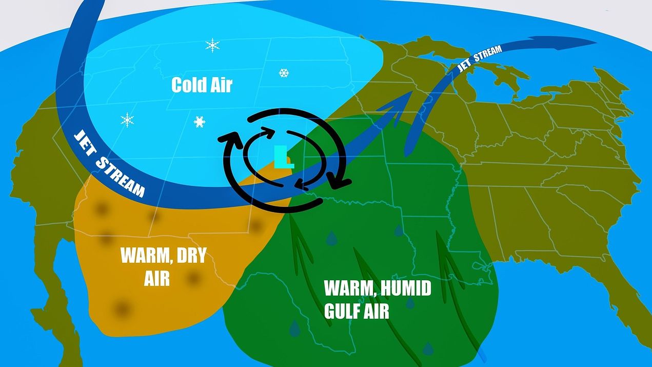
The National Weather Service has identified an enhanced risk of tornadoes across portions of the South, urging residents to stay vigilant. Yellow-shaded areas on forecast maps signal elevated dangers, while brown regions indicate significant threats. Hatched zones highlight spots where any developing tornadoes could pack exceptional strength. Officials emphasized that high humidity levels might conceal these storms, complicating detection efforts.
Risk Levels Explained
Forecasters delineated specific threat categories to guide preparedness. The yellow zones represent an enhanced probability of tornado formation, a step above marginal risks seen in routine weather patterns. Brown areas elevate concerns further, pointing to a significant likelihood of multiple tornadoes. Within these, hatched overlays mark territories particularly vulnerable to intense, damaging winds.
This tiered system helps communities gauge urgency. It draws from real-time data on atmospheric instability and wind shear, factors that fuel severe weather outbreaks. Residents in affected areas received tailored alerts to prioritize safety measures early.
Hidden Dangers in Rain-Wrapped Storms
Today’s potential tornadoes carry an added layer of peril due to environmental conditions. High humidity often shrouds funnels in heavy rain, rendering them nearly invisible from afar. Such rain-wrapped events strike without the typical visual cues, like a distinct funnel cloud against clear skies. This invisibility heightens the need for reliance on official warnings over personal observation.
Forecasters noted these traits in their assessments. Storms embedded in broader rain systems can spin up rapidly, leaving little time for reactions. Past outbreaks demonstrated how such concealed twisters inflicted surprise damage, underscoring the forecast’s gravity.
What matters now: Heed warnings without delay – visibility challenges make every second critical.
Essential Actions for Protection
When a tornado warning activates, immediate shelter becomes non-negotiable. The National Weather Service advised against venturing outside to spot the storm, a common but hazardous impulse. Sturdy interior rooms or basements offer the best defense against winds and flying debris. Communities practiced these drills in prior seasons, yet reminders persist amid evolving threats.
Preparation extends beyond the moment of warning. Stocking emergency kits with water, flashlights, and radios ensures readiness. Local authorities coordinated with broadcasters to disseminate updates swiftly. This proactive stance has mitigated impacts in previous high-risk scenarios.
- Seek shelter in the lowest level of a sturdy building.
- Avoid windows and exterior walls.
- Monitor NOAA Weather Radio or apps for real-time alerts.
- Assist neighbors, especially those in mobile homes or vehicles.
Staying Ahead of the Storm
The forecast serves as a call to action rather than cause for alarm. Enhanced risks like these arise from clashing air masses, a hallmark of spring weather in the South. Monitoring evolves hourly, with updates refining the outlook. Residents who tuned into briefings reported feeling more equipped to respond.
As conditions unfold, the focus remains on lives and property. Swift adherence to guidance has proven effective time and again. This episode reinforces the value of trusted sources in navigating nature’s unpredictability, leaving communities better poised for whatever develops.


