
A Strong El Niño May Be Coming. Global Warming Is Changing Its Effects. – Image for illustrative purposes only (Image credits: upload.wikimedia.org)
Farmers across the U.S. Southern Plains have endured six years of persistent drought, straining crops and water supplies. A developing El Niño could finally deliver the rains needed to break this cycle, yet global warming introduces uncertainties that past patterns no longer predict reliably.[1] Scientists now warn that warmer oceans alter the phenomenon’s intensity and reach, potentially amplifying extremes from floods to heatwaves worldwide.
Pacific Signals Point to Imminent Shift
Equatorial Pacific sea surface temperatures have edged above average in recent weeks, marking a departure from the neutral conditions that dominated early 2026. Subsurface heat content continues to build, with positive anomalies strengthening across the east-central Pacific since March.[2][3] Westerly wind bursts over the western Pacific further support this transition, suppressing convection over Indonesia while enhancing it near the Date Line.
The National Oceanic and Atmospheric Administration’s Climate Prediction Center reported ENSO-neutral favored through April-June at 80 percent probability. However, El Niño emerges as the leading outlook for May-July, with a 61 percent chance of development and persistence through year’s end.[2] Model ensembles like the North American Multi-Model Ensemble reinforce this view, projecting a Niño 3.4 index peaking potentially above 2 degrees Celsius by autumn.
From Neutral to Potentially Supercharged
Forecasts now suggest this El Niño could rank among the strongest, with median projections hitting 2.2 degrees Celsius in the Niño 3.4 region by September – crossing into “super” territory above 2 degrees.[4] For late 2026 into early 2027, probabilities split nearly evenly: 25 percent each for very strong, strong, or moderate events. Only a slim chance remains for prolonged neutrality.
Upper-ocean conditions mirror those preceding past major El Niños, including reduced thermocline slope and expanding warm subsurface waters. Yet early spring predictions carry inherent uncertainty, as atmospheric responses must align to sustain the warming.[3] The first quarter of 2026 already ranked fourth-warmest on record despite lingering La Niña influences, setting the stage for escalation.
Warming Oceans Demand New Forecasting Tools
Rapid Pacific warming has blurred traditional El Niño detection, prompting NOAA to adopt the Relative Oceanic Niño Index earlier this year. Unlike the Oceanic Niño Index, which compared anomalies to sliding 30-year baselines, RONI subtracts broader tropical Pacific trends to isolate true event signals.[5] This adjustment better links ocean changes to atmospheric shifts, revealing intensities that older methods understated.
Michelle L’Heureux of NOAA noted the prior approach increasingly captured non-ENSO warming, like viewing the ocean through “blurry glasses.” The new index sharpens focus, aiding earlier warnings amid a baseline that has warmed the tropical Pacific disproportionately.[5] Research indicates climate change may intensify events, shifting rainfall extremes eastward during El Niños and heightening overall volatility.[6]
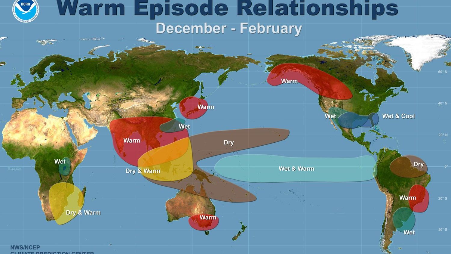
Real-World Ripples for Communities
El Niño’s warmth typically spikes global temperatures three months after peaking, positioning 2027 for record contention if this event strengthens. Carbon Brief estimates a 62 percent chance of 2026 as the second-warmest year, with 19 percent odds of topping 2024’s mark.[4] Regional effects vary sharply, redistributing rain in ways that challenge agriculture and infrastructure.
Key potential impacts include:
- U.S. Southern Plains and Southwest: Increased winter rains could ease droughts but risk flooding.[1]
- Southern California: Wetter conditions, potentially stormy winters.[7]
- Amazon and Australia: Heightened drought risks, threatening ecosystems and farms.
- Atlantic hurricanes: Fewer storms, but more activity in the Central Pacific.[8]
- Global south: Weakened monsoons in South Asia, exacerbating food insecurity.
Arctic sea ice hit a record-low winter peak in March, tying 2025 at 14.29 million square kilometers, underscoring compounded pressures.[4]
As models refine through summer, communities from parched farmlands to coastal cities brace for outcomes where historical guides falter. The interplay of natural cycles and human-driven heat leaves little room for complacency, pressing the need for adaptive strategies in an evolving climate.