
Summer 2026 Forecast Shift: New Data Shows a Stronger El Niño Impact Than Previously Expected – Image for illustrative purposes only (Image credits: upload.wikimedia.org)
As summer travel plans take shape across North America and Europe, meteorologists have issued a pivotal update on the season ahead. Oceanic data released this week revealed that an El Niño event is intensifying more rapidly than models predicted just weeks ago, steering toward what experts term a super El Niño by mid-year.[1][2] This acceleration ends a prolonged La Niña phase and promises widespread adjustments to temperature, precipitation, and storm risks.
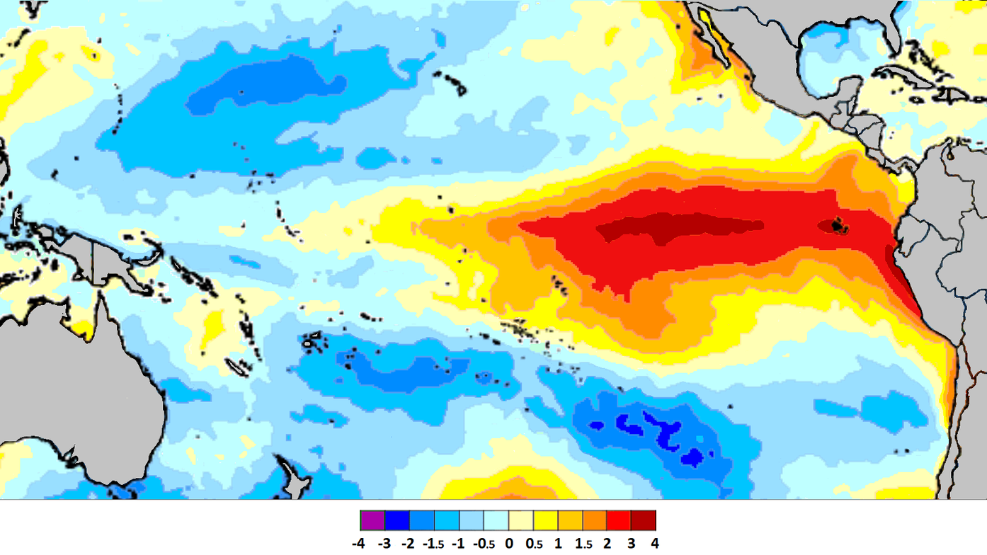
Oceanic Forces Fuel the Surge
Forecasters tracked a robust oceanic Kelvin wave propelling warm waters eastward across the equatorial Pacific. This subsurface pulse, now registering anomalies up to eight degrees above average at depths between 50 and 250 meters, dismantled lingering La Niña cool spots.[1] Surface temperatures in the key Niño 3.4 region cleared of cold influences, paving the way for sustained warming.
Long-range models from the European Centre for Medium-Range Weather Forecasts and the United Kingdom Met Office captured this momentum in their latest runs. The shift appeared in pressure pattern anomalies, with El Niño’s signature emerging more prominently than in prior projections. Trade winds weakened, further amplifying the warm pool’s expansion.
North America Braces for Cooler Eastern Summers
Eastern and central United States residents could encounter milder conditions than typical heat waves might suggest. Persistent low-pressure systems over the eastern seaboard and Great Lakes fostered northerly airflow, curbing extreme highs in those areas.[1][3] Meanwhile, the Pacific Northwest and western Canada faced prospects of above-normal temperatures.
These patterns stemmed from the jet stream’s reconfiguration under El Niño influence. Precipitation chances rose in the Northeast and parts of the Midwest, potentially easing fire risks but challenging outdoor schedules. Farmers in the central Plains noted the forecast’s implications for crop cycles, with balanced moisture aiding yields in vulnerable zones.
- Below-normal temperatures: Northern, central, and eastern U.S.; much of Canada.
- Above-normal heat: Pacific Northwest, western Canada.
- Increased rainfall potential: Eastern U.S., Great Lakes region.
Europe’s Drought Concerns Escalate
Central Europe grappled with signals of persistent dry spells amid the El Niño buildup. High-pressure dominance over the continent hinted at reduced rainfall, heightening drought vulnerabilities in agricultural heartlands.[1] Mainland temperatures trended warmer overall, straining water resources during peak demand.
Western regions might see occasional relief from Atlantic lows, but models emphasized a broader arid bias. This setup echoed dynamics from past strong El Niño summers, where suppressed storm tracks limited convective activity. Hydrologists monitored river levels closely, as prolonged warmth compounded soil moisture deficits.
Hurricane Season Finds a Natural Brake
The Atlantic basin entered 2026 with an unexpected ally against tropical threats. El Niño’s high-pressure ridge and enhanced wind shear over the main development region promised to suppress storm formation.[3] Fewer systems overall, though any that formed carried potential for rapid intensification.
U.S. coastal communities welcomed the reduced landfall odds, attributing the shield to vertical wind variations peaking mid-season. Caribbean islands and Gulf states prepared for selective risks, focusing preparedness on stronger outliers. This dynamic contrasted with La Niña-fueled active periods, offering a measure of predictability.
Global Ripples and Long-Term Watch
Beyond the Atlantic, the super El Niño loomed as a planetary heat releaser, influencing Southern Hemisphere winters with drier Australian conditions and crop stresses in parts of Asia and Africa.[3] Northern Hemisphere summers absorbed the first atmospheric responses, setting the stage for intensified winter patterns later in the year.
Seasonal model ensembles projected Niño 3.4 indices surpassing 2.0 degrees Celsius, rivaling historic peaks like 2015-16. Communities adapted by revising water management and energy demands. As the Kelvin wave fully surfaces, ongoing observations will refine these trajectories, underscoring nature’s capacity for swift pivots. For now, the forecast urged vigilance amid the promise of a transformed summer.