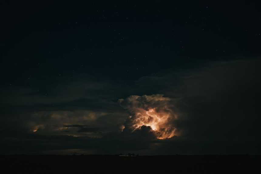


Supercell Thunderstorm Sparks Alarm (Image Credits: Unsplash)
Fresno County – Residents witnessed a dramatic display in the skies Thursday evening when a funnel cloud formed amid flashes of lightning. The rare sight served as an early warning of unsettled weather gripping the Central Valley. Meteorologists confirmed the event stemmed from a powerful supercell thunderstorm, heightening concerns for more severe conditions.[1][2]
Supercell Thunderstorm Sparks Alarm
A rotating funnel cloud emerged from a well-organized supercell thunderstorm near Firebaugh around 5:30 p.m. Observers captured video showing the cloud’s distinct rotation, prompting immediate attention from weather experts. Radar detected gate-to-gate rotation and a hook echo, classic signs of potential tornado development.[1]
Though no tornado touched down, the formation underscored the storm’s intensity. Ground reports described a visibly spinning cloud base, confirming at least a funnel cloud. The National Weather Service issued a tornado warning based on these indicators, urging caution across Fresno County and nearby areas.[1]
Warnings and Expert Analysis
Meteorologist Emily Wilson from the National Weather Service explained the rapid escalation. “We had been seeing some rotation in the radar signature, and that prompted us to issue that warning,” she stated. “We also saw a distinct hook echo in reflectivity, which would indicate there was some rotation in there.”[1]
Wilson noted reports of a spinning cloud and possible funnel cloud, supported by shared video. “It looked very well organized and was definitely rotating quite a bit,” she added. “We also received video of it, and it appears it was at least a funnel cloud, but not an actual touchdown.” No injuries or damage resulted from the event.[1]
Community Shares Eyewitness Accounts
Local resident Mary Luna captured striking footage near Firebaugh, which the National Weather Service highlighted on social media. The video depicted the thunderstorm’s tremendous structure under darkening skies. Such captures provided valuable data for forecasters tracking the system’s path.[1]
Thunderstorms remain uncommon in the Central Valley, making Thursday’s display particularly noteworthy. Residents expressed awe and vigilance online, sharing photos of lightning illuminating the horizon. These accounts helped paint a fuller picture of the storm’s reach across Fresno, Merced, and Mariposa counties.[1]
Forecast Points to Heightened Risks
Forecasters predict continued thunderstorm chances through the weekend, with Friday’s setup appearing stronger. Probabilities range from 30% to 50% in affected areas, carrying risks of hail, gusty winds, and isolated funnel clouds. “There are chances for thunderstorms through at least Sunday,” Wilson warned. “For tomorrow, the setup actually looks stronger than what we saw today.”[1]
Officials advise monitoring updates closely, as conditions could change rapidly. The broader system may deliver lightning, strong winds, and even another tornado, though probabilities remain low. Residents should prepare for potential disruptions.[3]
Severe weather preparedness includes the following key steps:
- Stay informed via local alerts from the National Weather Service at NWS Hanford.
- Secure outdoor items against high winds and hail.
- Seek shelter immediately if rotation or funnel clouds appear.
- Avoid flooded roads during heavy rain.
- Report sightings to local authorities or spotter networks.
Key Takeaways
- A supercell produced a funnel cloud near Firebaugh, but no touchdown occurred.
- Tornado warning issued based on radar rotation; video confirmed visuals.
- More thunderstorms likely Friday through Sunday with severe potential.
This episode reminds Central Valley communities of nature’s unpredictability. While no major impacts materialized Thursday, vigilance ensures safety amid the forecast turbulence. What do you think about these rare weather events? Tell us in the comments.