
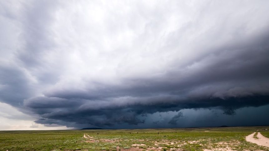

Understanding the Shelf Cloud Phenomenon (Image Credits: Unsplash)
A striking shelf cloud rolled across the skies over Goodland on Wednesday, drawing eyes skyward amid typical Plains volatility.[1][2] Captured by local agriculture firm Frontier Ag Inc., the formation highlighted the region’s active spring weather patterns. Residents witnessed the low-hanging, arc-shaped cloud as it advanced, a harbinger of gusty winds and heavier precipitation.
Understanding the Shelf Cloud Phenomenon
Shelf clouds emerge from the interaction of a thunderstorm’s downdraft with surrounding air. Cool, rain-laden air surges outward along the ground, lifting warmer air ahead of it and forming a distinct, shelf-like bulge under the storm cloud base. This visual spectacle often stretches for miles.
Forecasters distinguish shelf clouds from more dangerous wall clouds, which hang lower and may signal rotation for tornadoes. The Goodland sighting showed classic traits: a sharp, horizontal edge contrasting against clearer skies behind it. Such features alert observers to imminent strong winds, sometimes exceeding 60 mph.
Spring Severe Weather Context in Western Kansas
Western Kansas enters peak severe weather season each spring, with thunderstorms fueled by clashing air masses. The National Weather Service office in Goodland recently issued outlooks for isolated supercells capable of large hail, damaging winds, and brief tornadoes, particularly south and east of nearby Oakley.[3][4] Conditions on April 26 featured morning showers limiting instability, yet potential lingered for potent storms.
April 2026 brought scattered severe activity across Kansas, including baseball-sized hail in east-central areas earlier in the month.[5] Goodland’s location on the High Plains exposes it to frequent gust fronts from mesoscale convective systems. Wednesday’s shelf cloud fit this pattern, arriving with light showers under cloudy skies and temperatures in the mid-50s.[6] Forecasts called for overcast conditions with east-northeast winds.
Local monitoring remains crucial. The NWS Goodland tracks these events closely, updating hazards as systems evolve. Earlier outlooks emphasized reduced thunderstorm coverage due to cloud cover, but any development carried risks.
Frontier Ag Inc.’s Role in Weather Documentation
Frontier Ag Inc., based in Goodland, maintains SkyView cameras offering live feeds and timelapses from multiple directions: north, south, east, and west.[7] These resources, available at Frontier Ag SkyView, frequently capture dynamic sky changes over the agricultural landscape.
The firm’s Wednesday image spread rapidly online, shared via a r/weather post credited to them.[1] Such contributions aid public awareness, especially in rural areas where professional spotting complements official reports. Timelapses from recent days, including early April views, showcase similar cloud movements.
Key Safety Takeaways for Plains Residents
- Shelf clouds precede gust fronts; seek shelter if winds intensify.
- Monitor NWS alerts for hail, lightning, or flash flooding risks.
- Distinguish from wall clouds: shelf clouds arc horizontally, not pendulous.
- Secure outdoor items ahead of storms in farm country.
These formations remind locals of the Plains’ unpredictable weather. While Wednesday’s event passed without major reports, vigilance persists into May.
As spring progresses, Goodland’s clear skies often yield to such displays, blending beauty with caution. Frontier Ag’s vantage points ensure these moments endure, informing both farmers and weather enthusiasts about the forces shaping the High Plains.


