
Tuesday, 17 Nov 2026
Las Vegas News
  • About Us
  • Our Authors
  • Cookies Policy
  • Disclaimer
  • Contact Us
  • Privacy Policy
  • News
  • Politics
  • Education
  • Crime
  • Entertainment
  • Las Vegas
  • Las
  • Vegas
  • news
  • Trump
  • crime
  • entertainment
  • politics
  • Nevada
  • man
Las Vegas NewsLas Vegas News
Font ResizerAa
  • About Us
  • Our Authors
  • Cookies Policy
  • Disclaimer
  • Contact Us
  • Privacy Policy
Search
Have an existing account? Sign In
Follow US
© 2022 Foxiz News Network. Ruby Design Company. All Rights Reserved.
News

Odisha Braces for Intensifying Cyclonic System Expected to Deliver Widespread Rain and Storms

By Matthias Binder May 8, 2026
Low pressure system to trigger rain in Odisha, likely to intensify into depression
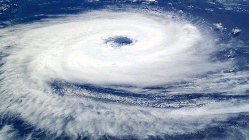
Low pressure system to trigger rain in Odisha, likely to intensify into depression - Image for illustrative purposes only (Image credits: Pixabay)
SHARE

Low pressure system to trigger rain in Odisha, likely to intensify into depression

Contents
System Builds Over the Andaman SeaYellow Warnings Issued for Thunderstorms and WindsDistrict-Level Forecast for the Coming DaysPrecautions for Coastal Communities and Emergency Services

Low pressure system to trigger rain in Odisha, likely to intensify into depression – Image for illustrative purposes only (Image credits: Pixabay)

Odisha – The India Meteorological Department has placed the state on alert after a cyclonic circulation formed over the South Andaman Sea and began moving toward the coast. The system, which currently reaches 1.5 kilometers above sea level, is forecast to strengthen into a low-pressure area by May 12 or 13 and could develop further into a depression in the days that follow. Forecasters expect the change to bring several days of rain, thunderstorms, and gusty winds across much of the state.

System Builds Over the Andaman Sea

The circulation developed in the southern Bay of Bengal region and has already begun influencing weather patterns along the eastern coast. Meteorologists note that warm sea-surface temperatures and favorable upper-level conditions support gradual intensification. If the system reaches depression strength, rainfall totals could increase sharply in coastal and interior districts alike. The timeline places the most active phase in the middle of next week, giving residents and authorities a short window to prepare.

- Advertisement -

Yellow Warnings Issued for Thunderstorms and Winds

For the next 24 hours, the department has issued a yellow alert covering thunderstorms accompanied by lightning and surface winds reaching 40 to 50 kilometers per hour. The warning applies to districts including Mayurbhanj, Keonjhar, Balasore, Bhadrak, Sundergarh, Ganjam, and Gajapati, with the strongest activity expected during afternoon and evening hours. A separate yellow alert for the following day expands coverage to 20 districts for rain and thunderstorms, while advisories reach 30 districts in total. Officials stress that even moderate winds can damage temporary structures and disrupt power lines in exposed areas.

District-Level Forecast for the Coming Days

Light to moderate rain or thunderstorms are expected at one or two places over Mayurbhanj, Keonjhar, Balasore, Bhadrak, Sundergarh, Ganjam, Gajapati, Rayagada, Koraput, and Malkangiri through the morning of May 9. The remainder of the state is likely to see mainly dry conditions during the same period. Beyond the immediate forecast, the department anticipates that the strengthening system will spread showers more widely once it moves closer to the Odisha coast. Residents in low-lying areas have been reminded to monitor local updates as the pattern evolves.

Precautions for Coastal Communities and Emergency Services

Fishermen and residents along the shoreline have been advised to exercise extra caution while the system develops. Emergency response teams remain on standby to address any weather-related incidents, including localized flooding or wind damage. Authorities continue to emphasize simple steps such as securing loose objects, avoiding open areas during thunderstorms, and staying informed through official channels. The current setup highlights how quickly conditions can change during the pre-monsoon period in eastern India.

Previous Article DAY 1 SLIGHT SEVERE WEATHER RISK ACROSS MUCH OF OKLAHOMA…FORECAST SYNOPSIS…ISSUED MAY 08, 2026…11:45 A.M. EDT Oklahoma Faces Slight Severe Storm Threat
Next Article Weather Watch May 8, 2026, Manchester, NH, with Rick Gordon Chilly with a mix of sun and clouds, high near 59° (feels like 55°) and brisk WNW winds at 10–20+ mph. Manchester Braces for a Cool, Windy Wednesday as Spring Temperatures Lag
Advertisement
Advertisement
Advertisement
12 ’70s TV Spin-Offs – How Many Do You Remember?
Entertainment
If You Remember These 6 Gen X Cartoons, You Grew Up in a Different Era
Entertainment
Dreaming of a Career in Hollywood? 6 Things Retired Actors Wish They’d Known Sooner
Entertainment
9 TV Episodes Fans Automatically Skip on Every Single Rewatch
Entertainment
The "Skip the Sequel" List: 9 Franchise Follow-Ups That Damaged the Original
The “Skip the Sequel” List: 9 Franchise Follow-Ups That Damaged the Original
Entertainment
Categories
Archives
November 2026
M T W T F S S
 1
2345678
9101112131415
16171819202122
23242526272829
30  
« Oct    
- Advertisement -

You Might Also Like

‘It’s about results’: Carlos Giménez endorses Scott Singer for Congress
News

Carlos Giménez Champions Scott Singer’s Record in Florida’s Redrawn 25th District Race

May 5, 2026
News

Officers: 3 damage in capturing spree that began in Las Vegas, led to California

April 2, 2025
Planet X's art remains an outworldly Nevada treasure
News

Planet X Pottery: Nevada Desert Art That Turned a Remote Homestead into a Lasting Oasis

May 10, 2026
StormCircle is still being updated!
News

StormCircle Keeps Hurricane Tracking Active

May 7, 2026

Interested in working with us? Explore Advertising Opportunities.

© Las Vegas News. All Rights Reserved – Some articles are generated by AI.

A WD Media Brand.

Welcome to Foxiz
Username or Email Address
Password

Lost your password?